
Exit

Stareway to heaven

Trapez
Exit


Climb:
There are several areas in Leukerbad and the surrounding area
to climb and prepare for the via ferrata.
A helmet is recommended in all climbing areas.
The use of the climbing areas is at your own risk
Responsibility. Any liability is expressly excluded
rejected.
Climbing areas (see map)
Climbing Leukerbad:
Climbing area Chalet Mengis (5 routes)
at the top of the village - direction Regina Therme
Follow the road to the roundabout with the fountain.
The climbing area is about 30m to the right of the roundabout.
CH1903 / LV03614486 137321
CH1903+ / LV952614486 1137321
long/lat:WGS847.62695 46.3871
Altitude 1551.2 m

Klettern Leukerbad:
Klettergebiet Chalet Mengis (5 Routen)
zu oberst beim Dorf - Richtung Regina Therme
Strasse bis zum Kreisel mit Brunnen folgen.
Das Klettergebiet ist ca.30m rechts vom Kreisel.
CH1903 / LV03614486 137321
CH1903+ / LV952614486 1137321
long/lat:WGS847.62695 46.3871
Höhe 1551.2 m


Klettergebiet Tolen - ( Total 23 Routen: 12 Routen (max.6b) + 11 Einsteiger, Kinder- und Jugendkletterrouten)
Helm obligatorisch
Vom Klettergebiet Chalet Mengis ca.400m Richtung Melcherboden. Auf der Naturstrasse nach der ersten Verzweigung gerade aus laufen. Ca.100 m auf der Höhe einer Felswand links dem Flurweg (5om) folgen. Die Wand befindet sich auf der linken Seite des Flurweges.
CH1903 / LV03614708 137377
CH1903+ / LV952614708 1137377
long/lat:WGS847.62984 46.3876
Höhe 1599.5 m
Topos auch auf Topoapp.ch (gratis)


Climbing area at Leitergraben (near the Albinenleiter - no topo available yet).
Difficulty level >6b
Climb up the stream bed for approx. 50 m on the bridge. On the right is the climbing area (seen from below).
.
CH1903 / LV03614174 134573
CH1903+ / LV952614174 1134572
long/lat:WGS847.62281 46.36238
Altitude 1382.0 m
Climbing Gemmi:
Gemmi (Topos among others in the Upper Valais climbing guide or onTopoapp.ch (free))


Der Sektor E ist noch nicht realisiert, Sektor A und B werden selten geklettert.
Sektor Jägerboden (Kinder - und Jugendkletterrouten)
Die Routen (ca. 10-15) im Gebiet Jägerboden haben einen Schwierigkeitsgrad von 3 - 6a.
Standort Jägerboden:
CH1903 / LV03612903 138524
CH1903+ / LV952612903 1138524
long/lat:WGS847.6064 46.39795
Höhe 2259.0 m


Area sun garden 1+2


Sektor Gemmibahn
(Zugang via Erlebnisklettersteig)

Lämmerenhütte (topos on the homepage) oder here as PDFdownload
Ideal climbing area for children and beginners.

Schwarenbach (above mountain restaurant)
Location coordinates:
CH1903 / LV03613893 142809
CH1903+ / LV952613893 1142809
long/lat:WGS847.6194 46.43648
Altitude 2321.0 m

Climbing region Leuk:
Salgesch
Routes from 3c to 7c
Longest route 150m max 3c
Longest rope length 33 m 6a+
Most rope lengths are between 15 and 25 m long.
CH1903 / LV03612038 128967
CH1903+ / LV952612038 1128966
long/lat:WGS847.59492 46.312
Altitude 601.8 m

Sector dynamo:

1 Oh Lax 5c
2 Riccilix 6a
3 La Gala 6a+
4 Attrition 7c
5 Va z'Fleigisch 7a+
6 Beschy 7c
8 promise 6c
9 snake hole 6b
10 dynamo 6
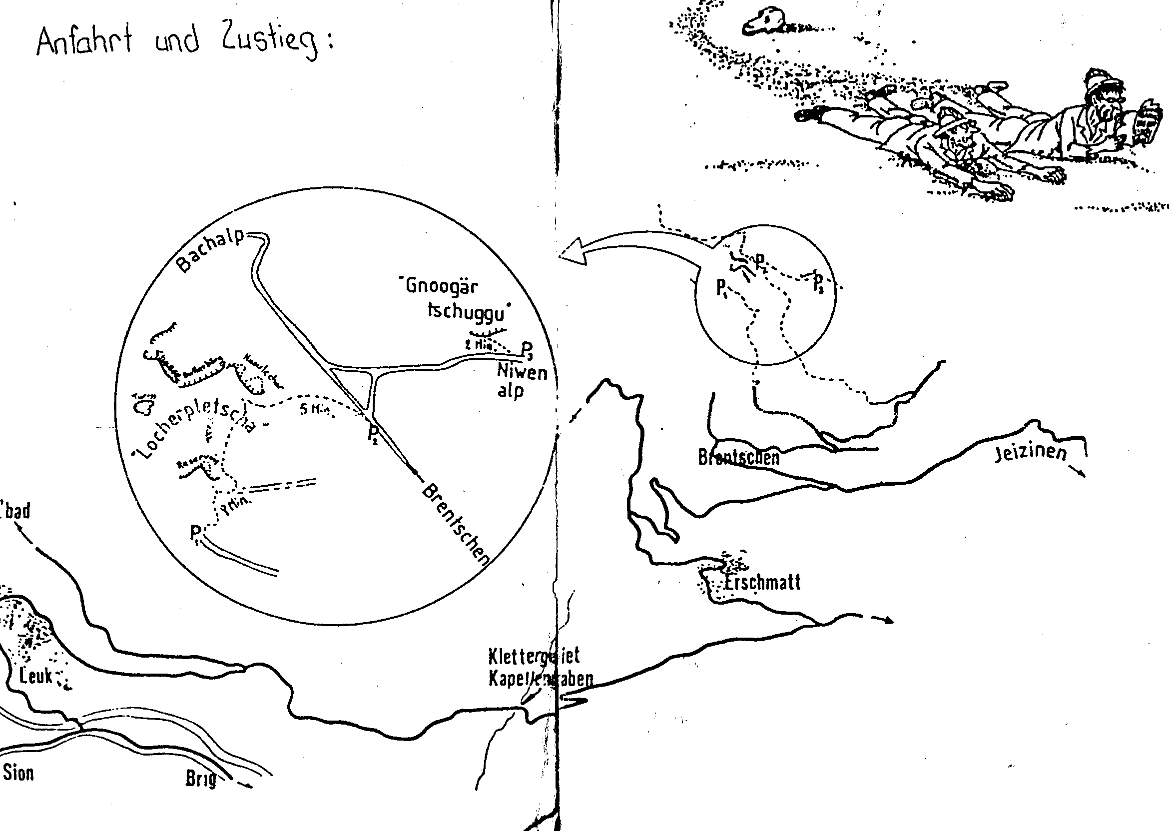
Brentschen
getting there
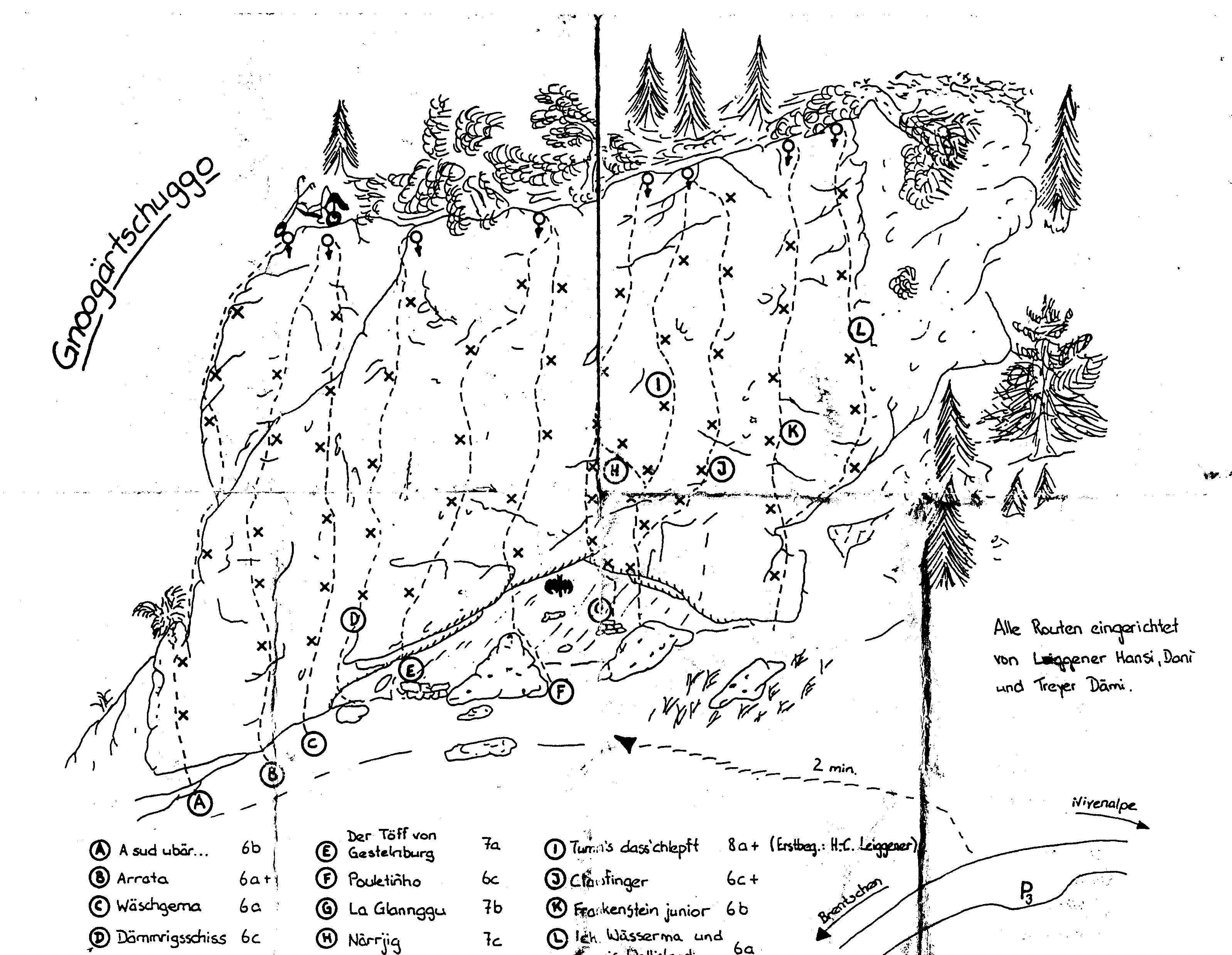
Topo Gnoggertschuggu
Topo Gnoggertschuggu
Topo Locherplescha
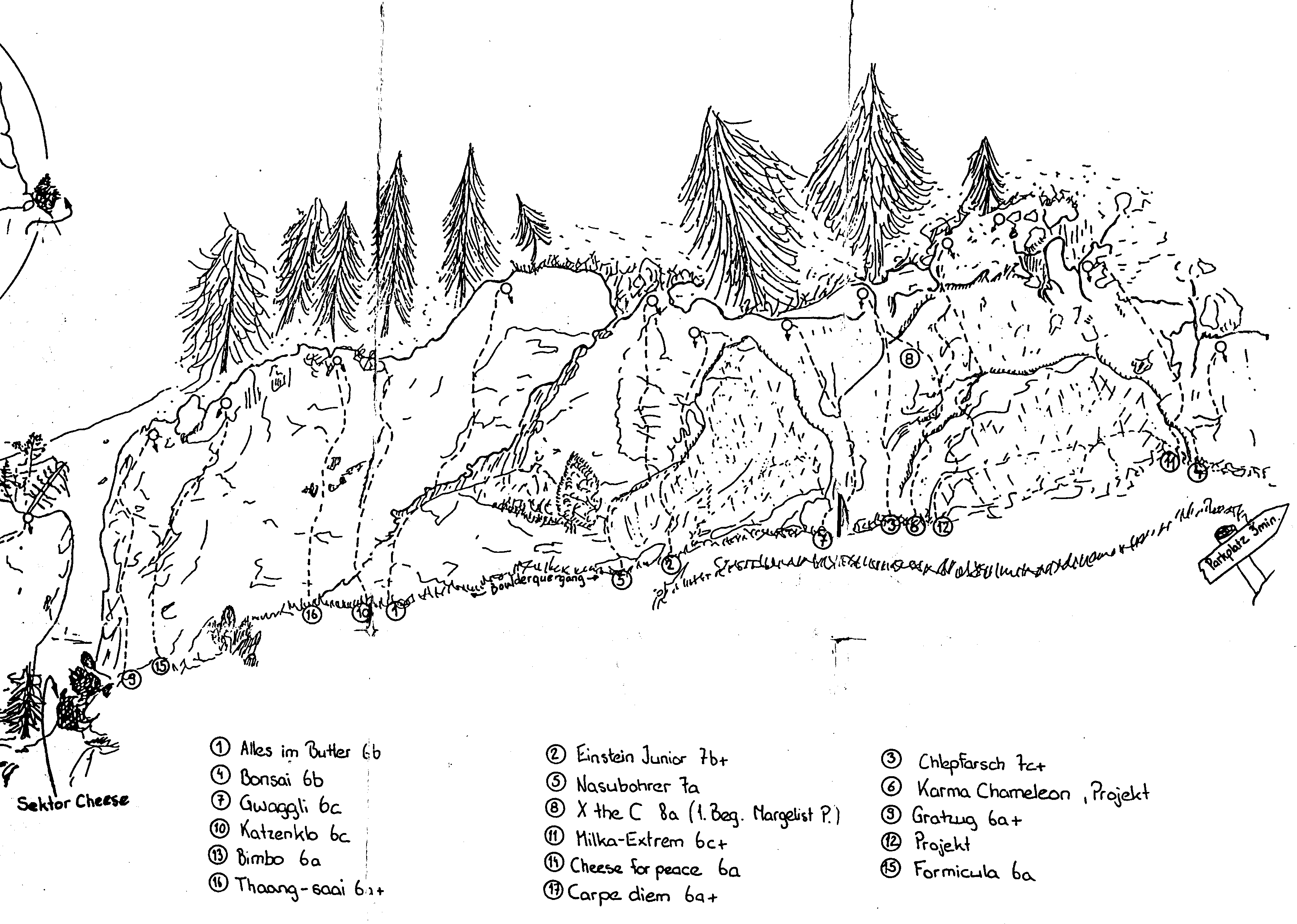
Pfynpfyler

Feschelloch


- Outdoor Bouldering Almei (5 min walk from the village of Leukerbad towards Gemmi).
More
- Div. climbing areas in the valley (see climbing guide Plaisir West and www.valgrimpe.ch).
- Oberwalliser Kletterführer www.raglu.ch
Staying in the area of the climbing gardens and walking the routes is at your own risk.IG Klettersteig declines all liability (particularly for consequences resulting from any incorrect information in the route descriptions or from insufficient safety hooks or loose grips/steps breaking out or from falling rocks).